Windrush Weather

Category: Commentary

  • Unsettled weather as low-pressure systems circle around us

    Unsettled weather as low-pressure systems circle around us

    Thursday gave us a very cloudy morning and early afternoon that limited the rise in temperature to a maximum at 13.38 of 25.9C, being 3.2C above average. That broke the recent pattern of heat building throughout the afternoon. The reason was a very moist air stream from a warm weather front that crossed during the day. This weather pattern gave us another very mild night with a low of 16.0C at 03.41, which was 4.1C above average. The humidity at 16.00 was high at 64% and by 18.00 had risen to 78% when last week I was registering humidity around 40% in the afternoons.

    The start to Friday was in contrast to recent mornings as the very moist air and low cloud meant the Marlborough Downs and Savernake Forest were draped in cloud. Initially, the visibility was limited to 500m, but this improved very quickly that by 07.50 had lifted into low cloud. The humidity at 08.00 was 89.1%, the second highest this month. The cloudier conditions today are thanks to a cold front crossing the UK. There are currently three modest low pressure systems around the UK so unsettled conditions are likely for the next few days, with sunshine and possible showers also less extreme temperatures.

    The recent heatwaves made headline news with three in succession have occurred in 2025, so far, when the heat threshold for Wiltshire of 27C was equalled or exceeded. I have analysed the last thirty years of my records to find the incidence when a daily maximum of 27C was equalled or exceeded and discovered a distinct rising trend over that period. In the early 1990’s there was an average of 7 days when those conditions were met whereas in the 2020s that figure had risen significantly to 14 each year, on average. The extremes were in 1998 when no days reached a maximum of 27C, which contrasts with the year of 2018 when 28 days of 27C or above were recorded. This year we have so far had 13 days when the maximum of 27C or above was recorded.

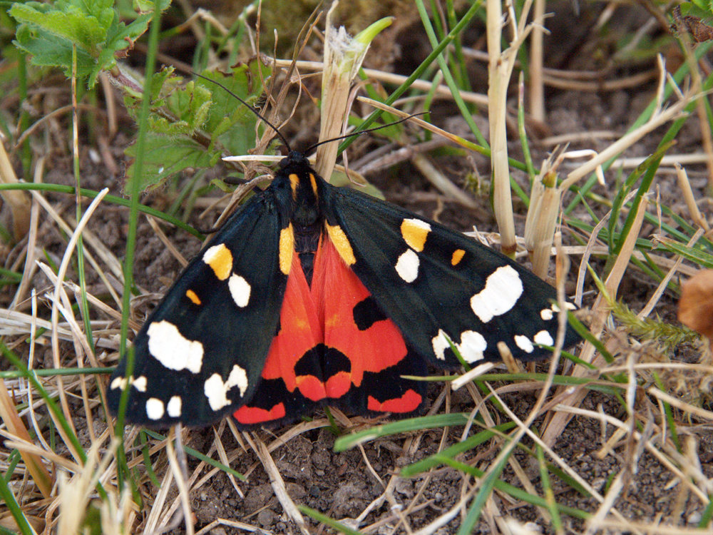
    The image is of a scarlet tiger moth, active during day and night. It flashes its red hindwings as a warning to predators.

  • Warm, moist air today from the Atlantic

    Warm, moist air today from the Atlantic

    The temperature recovered on Wednesday with a maximum of 25.4C early in the afternoon being 2.7C above average. This early afternoon peak was the result of thin cloud beginning to edge in from the west after around midday and then thickening, hence no further rise as the afternoon progressed as occurred during previous, hot days. Once again, overnight cloud cover meant a mild night, an exceptionally mild night, with a low of 17.6C at 05.46 being 5.7C above average. The low was only 5C below the average maximum for July.

    Thursday revealed a cloudy start to the new day with misty conditions before 06.00 over the Marlborough Downs, albeit with some brightness in the east first thing. There was evidence on smooth surfaces of some precipitation, so I suspect light drizzle had fallen a little earlier. The cloud is thanks to a warm weather front slowly crossing the country today bringing not only warmth but moist air from the Atlantic. The humidity at 08.00 was 81.5%, the highest since the 7th when 91.9% was logged after the light rain on the previous day. The barometric pressure at 08.00 read 1017.5mb up just 1mb since Wednesday.

    The high pressure will slowly east eastwards over Scandinavia and Russia as the day progresses with a low pressure system to the northwest trying to edge closer today and tomorrow, however, this will not have a major effect on what will be a hot, dry day on Friday, thanks to the residual high pressure. It will be Saturday and Sunday before we come under the influence of the depression as it then centres over the UK with lower temperatures and more cloud.

    The total July rainfall to date is just 11.4mm being only 19% of my 41-year record. Set against the minimal rainfall is the equivalent loss of rainfall due to evaporation from ground sources and plant life that now totals 71mm. Although the daily total varies according to the weather there has been an average loss of over 4mm each day, the greatest loss was 6mm on the 12th under the blazing sun and very high temperatures. By contrast there was loss of just 2.3mm on the 15th under the more moist southwesterly breeze and lower maximum.

    The butterfly is a Hedge Brown on Ragwort

  • UK now firmly under Atlantic influence

    UK now firmly under Atlantic influence

    The morning and early afternoon on Monday were noticeable for the almost continuous and variable cloud cover that brought a light shower just before 14.00 with light drizzle in the evening, observed around 20.00, that amounted to 1.1mm. The additional precipitation took the monthly rainfall to just 11.4mm when the 41-year average for July is 59.8mm. The sun broke through mid-afternoon that saw the UV level climb to ‘High’ and produced a maximum temperature of 21.1C at 15.30 being 1.6C below average. For most of the day the wind was very brisk with a peak gust of 22mph at exactly 11.00. There followed another mild night with the low of 13.0C logged at 05.23, just after sunrise was forecast in Marlborough at 05.08, however, a cloudy start to Tuesday meant strong sunshine was a little delayed until the sun got above cloud on the eastern horizon.

    Tuesday at 08.00 saw the sun shine strongly that had lifted the thermometer to 17.2C by 08.00, but variable light cloud then followed. The soil temperature at a depth of 5cm read 20.2C at 08.00, a drop of 7C since the peak on Saturday at the height of the heatwave. This drop is solely due to the lower daytime temperatures as the minimal rainfall we have received has only wetted the surface and not penetrated to any significant depth.

    A modest high pressure system has been slowly edging in from the Atlantic, ridging over southern England, so showers are unlikely today. However, a weather front and associated cloud has been edging in front the west, currently over Devon and Cornwall, that is likely to bring a cloudy start to Thursday but precipitation likely to be minimal, if any, as the barometric pressure continues to be relatively high with a reading of 1016.5mb at 08.00.

    The image is of a peacock butterfly on a begonia plant.

  • Unsettled – cooler and windy with possible showers

    Unsettled – cooler and windy with possible showers

    Monday saw the residual warmth of the heat wave as the thermometer eventually rose to a maximum of 23.6C at 15.28 that was moderated by a brisk wind from the southwest gusting at its peak to 20mph. This high was 0.9C above average but the coolest day since the 7th. The minimum overnight of 11.5C was just below average logged at 03.07 early Tuesday. During the day occasional spots of light drizzle were observed with very brief, light rain at 16.35 and a much heavier and intense rainfall at 21.00 that amounted to 4.1mm. This was the wettest day since 12th June, from a late passing shower, that topped up two water buts, which will be useful with a hosepipe ban in place from the 22nd. The temperature dropped almost 5C during the shower at 16.35.

    Tuesday brought weak sunshine to start the new day but just after 07.30 cloud began to blot out any sunshine. Today will be the first of the unsettled days this week with a cloudy day ahead and possible showers from a warm weather front crossing the UK associated with a depression just off the coast of Northern Ireland. This low pressure system will slowly migrate eastwards across central England with possible more rain for Southern England later in the day.

    There is an anticyclone lurking down to the southwest that will moderate our weather as the week progresses with the temperature recovering back well above average, but no heatwave. The week will also see the wind from a westerly or southwesterly direction under the influence of the Atlantic.

    The butterfly is a Meadow Brown on an Oxeye Daisy flower.

  • All change – cooler and breezier weak ahead so relief from the extreme heat

    All change – cooler and breezier weak ahead so relief from the extreme heat

    Sunday was the last day of the heatwave that saw the thermometer, late in the afternoon at 17.30, rise to 29.5C being 6.8C above average. Officially the heatwave lasted for five days when the threshold temperature for Wiltshire of 27C was exceeded. Cloud was observed beginning to ease in from the west just before 18.30 that muted the evening sunshine, however, it had the reverse affect overnight in minimising the loss of heat into the atmosphere, hence a very mild night with a minimum of 16.3C logged at 05.45 being 4.4C above average.

    Monday early revealed variable light cloud that limited the sunshine. The wind had veered into the southwest heralding the arrival of an Atlantic influence. The temperature at 08.00 was 19.5C, the coolest start to a new day at that time since Wednesday last week.

    We are now under temporary influence of a depression, centred just off the north coast of Northern Ireland, that has started to spread weather fronts across the UK last night, hence the cloudier, cooler conditions with higher humidity. The humidity at 08.00 was 75%, the highest for a week. The jet stream is currently racing across the Atlantic and running right across the country hence the wind will be stronger and from a westerly quadrant for the rest of this week, which will mean lower maxima than the past week.

    The extreme heat and intense sunshine this past week has seen the leaves of many vegetables and flowers, even if watered copiously, show clear signs of burning and shrivelling up, especially at the edges, as the rate of transpiration couldn’t keep up with the intake of moisture. I have just about emptied my five large water buts, with a capacity of almost 1500 litres, that were partially replenished with the light rain a week ago.

    The butterfly is a Green-veined white enjoying a visit to lavender, which has been very poplar with both butterflies and bees this past two weeks.