Windrush Weather

Author: Eric Gilbert

  • The sun returns!

    The sun returns!

    Surprisingly, Thursday did not see the cloud begin to thin and break as forecast. The cloud that had drifted in from the North Sea overnight persisted all day and in fact eased even further westwards as the day progressed. As a result the temperatures by day and night were depressed making it feel chilly in the brisk northeasterly breeze. The maximum of 15.4C was 1.9C below my long-term average making it the coolest day since the 6th. There were occasional glimpses of very brief bursts of sunshine when the cloud thinned. But overnight the cloud did disperse so that we had another cool night that saw the thermometer drop away to 5.2C at 05.34, just after sunrise at 05.14, being 1.8C below average.

    Friday brought us the return of welcome sunshine after sunrise that had lifted the temperature to 11.3C by 08.00. After 07.30 small areas of light, high cloud did drift across from the North Sea, on the continuing brisk northeasterly breeze, but minimal interruption of sunshine.

    The anticyclone, centred just to the north of Scotland, continues to push down south over the Uk and across France and built further, an increase of another 2mb since yesterday, with a barometric pressure reading of 1027.4mb at 08.00 making it the highest pressure all month and since 10th April. The forecast charts indicate that this high pressure will keep the dry, sunny weather well into next week.

    Unfortunately, I hadn’t realised that when the website was rebuilt at the end of last year it had inadvertently restricted the width of the data sheets, making viewing less than ideal. This situation, hopefully, will be addressed soon, not something I can remedy, I just fill in the spaces!

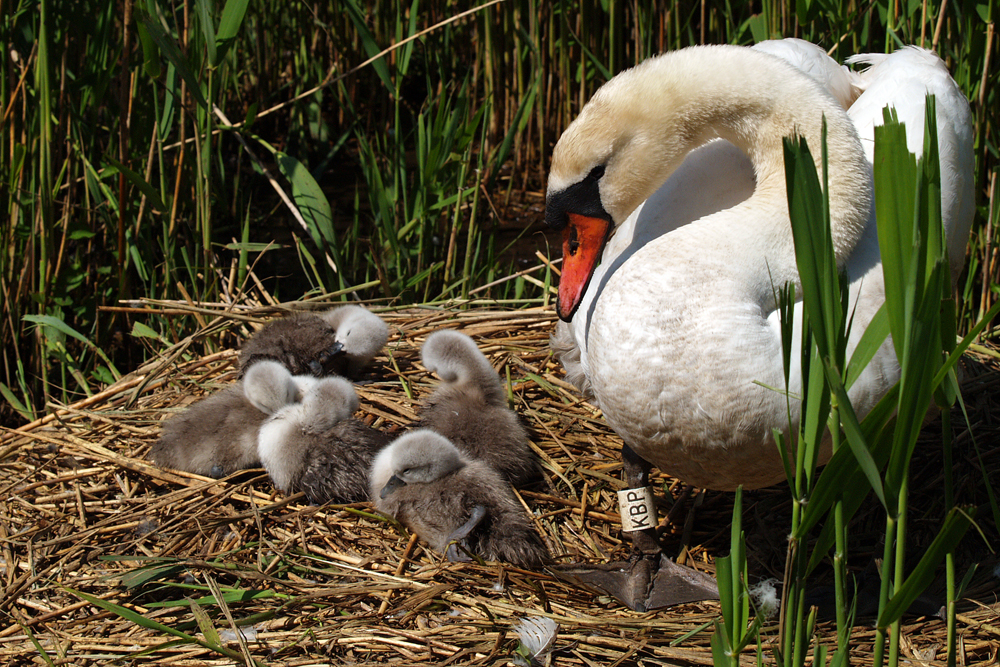
    There will be a new image each day from the Abbotsbury Swannery, that will continue into next week. The Swannery was established by Benedictine Monks who built a monastery at Abbotsbury during the 1040s. The monks farmed the swans to produce food for their lavish Dorset banquets.

  • Dominant high pressure holding firm

    Dominant high pressure holding firm

    The many hours of strong sunshine on Wednesday lifted the temperature to 22.1C by 15.35 being 4.8C above average. The wind continued brisk and from the northeast peaking at 15mph. Much comment has been made about the continuing dry spell, which was compounded yesterday as the equivalent loss of rainfall from evaporation from ground sources and plant life reached 5.0mm, the highest loss since 20th June, inflated yesterday due to the little residual moisture from the minimal rainfall of 0.5mm that fell on the previous day. Once again the past night was chilly that saw the thermometer reach a low of 5.9C at 04.19, which was again below average of -2.1C, before cloud drifted across again from the North Sea.

    Thursday revealed total cloud cover. Backtracking the cloud radar it was clear to see that thick cloud had drifted across from the cold North Sea, current sea temperature is 11C, arriving just after 04.00 that linked with the minimum temperature logged at at 04.19. The moist, cool air , not having been heated by early sunshine gave a humidity reading of 83.3% at 08.00. This cloud bank will, hopefully, thin and break up as the sun gathers strength during the morning. The thermometer had risen a little to 8.0C by 8.00, making it the coolest start to a new day for a week at that time, especially as wind chill was also factor making it feel only 7.0C outside.

    The dominant high pressure will stay centred just to the north Scotland and push further south, there has been a further rise of 3mb since yesterday. The projection of the Jet Stream track indicates that this situation will continue into next week. The wind track shows it currently originating just east of Iceland, then travelling south down across western Scandinavia before crossing the North Sea, thus a very cool air stream.

    A selection of images from Abbotsbury Swannery will be added each day, which is the only place in the world where people are able to walk through the heart of a colony of 600 nesting Mute Swans. The site is on the south coast, just east of Weymouth.

    Unfortunately, I hadn’t realised that when the website was rebuilt at the end of last year it had inadvertently restricted the width of the data sheets, making viewing less than ideal. This situation, hopefully, will be addressed soon, not something I can remedy, I just fill in the spaces!

  • Have we offended the rain gods?

    Have we offended the rain gods?

    Rain to the north and rain to the south of Marlborough over the past two days but barely a drop over our area, just 0.5mm, which very quickly dried up, that took the monthly rainfall total to 1.1mm when the 41-year average is 60.4mm. The thunderstorms were observed forming at 13.30, just to the south of area and then continued to build from Kent to Wales with the main storms travelling just south of Marlborough. As the air temperature increased during the latter part of the morning the air began to rise and in the unstable atmosphere where air from the depression and that from the North Sea met, began to condense, cooling as the gained height, then formed the storms. However, the warm sunshine continued during the morning and early afternoon with a maximum of 22.7C at 14.50 before the clouds thickened and rain spots were observed at 14.10, when I was out walking, but not measurable, and a very, very brief thundery shower at 15.55. The high was 5.4C above my long-term average. The past night was again chilly that saw the thermometer very slowly fall away to reach a minimum of 5.7C at 02.27, much earlier in the morning than has been recently been the case when nearer sunrise. This low was 1.3C below my long-term average.

    Wednesday brought us another glorious start to the day with splendid sunshine and not a cloud in sight. This resulted in the thermometer climbing to 11.2C by 08.00. As the anticyclone slowly relocates it has meant the wind direction backing into the northeast today and brisk.

    As mentioned in the report of previous days, the recent low pressure system has migrated back into the Atlantic and is currently still filling and by tomorrow will have disappeared. The high pressure has continued to build, up another 4mb since yesterday reading 1021.4mb at 08.00, and extended further southwards across the UK.

    The main Jet Stream, having travelled across the Atlantic, continues to loop northwards around the UK and then back southwards towards the Continent. This the pattern is referred to as an “Omega’ block as it resembles the Greek letter for Omega. It is in fact a blocking high pressure that is keeping any weather fronts and weather systems from advancing towards the UK from the Atlantic. The forecast charts indicate that this situation will continue into next week so we have a number of dry, sunny and warm days ahead.

    The images for the next week or so were taken at the Abbotsbury Swannery near Weymouth in 2006 that is home to over 600 mute swans. This time of year is perfect to visit and see the many hundreds of fluffy signets starting their new lives. Tomorrow I will post one of the images with an ah!!factor.

  • Rain passes us by!

    Rain passes us by!

    The thunderstorms did breakout as forecast but not over Marlborough. The rain radar showed a vigorous line of storms developing and spreading northwest from London, near Oxford and to the Midlands then Wales. As a result we had many hours of strong sunshine that lifted the temperature to a peak of 21.1C late in the afternoon at 17.28. This peak was 3.8C above my long-term average but less warm than on the previous two days. Initially overnight the sky remained mostly clear so the thermometer began to fall steadily but just after 01.00 thin cloud began to drift across from the depression that slowed the decline reaching a minimum of 6.3C at 05.47 just after sunrise at 05.19 in Marlborough. The UV level rose to a high level for the second consecutive day.

    Tuesday revealed a cloudy start the day after a little brightness before 06.30 as more cloud from the low pressure system over the Bay of Biscay continued to feed on a light easterly breeze.

    The depression is very slowly easing westwards into the Atlantic and gradually beginning to fill whilst the high premise to the north has been building down over the country with a rise of 7mb since yesterday with a reading of 1017.6mb at 08.00.

    Whilst gardeners and farmers bemoan the lack of rain since the end of February, the rate of evaporation from ground sources and plant life, surprisingly, continues at quite a high rate. Six days this month has seen in excess of 4mm of equivalent rainfall lost on each day. Whilst we had 0.6mm of precipitation on Sunday the total loss for May, from evaporation, now exceeds 40mm.

    The high pressure centred to the north of the UK will build a little higher whilst at the same time it will slowly extend its influence further south over the UK that will, from Wednesday, produce more fine, sunny and dry days with little sign of precipitation of any significance until after the weekend and, possibly well into the following week.

    This will be the last image of tulips from Malmesbury Abbey Gardens that I took in 2006. The following days will contain images from the Swannery at Abbotsbury near Weymouth, a home of over 600 mute swans.

  • Rain! But only a few drops, no quantity

    Rain! But only a few drops, no quantity

    After a sunny morning on Sunday the cloud built gradually after around 13.00 and then thickened before 15.00 that produced a few drops of rain at 15.15, also observed again just before 15.45, but not enough to wet the ground, I could count the number of drops per square metre there was so little when the gardens and fields are desperate for steady rainfall over a few hours. However, there was a light shower that started just before 06.00 early Monday that produced just 0.6mm of precipitation. The brief heavy showers were, once again, to the north of Marlborough, around Swindon, and west of Marlborough, Melksham would have had a heavy shower.

    The maximum temperature on Sunday was 24.3C being exactly 7C above my long-term average being the warmest day since the 1st when 28.1C was logged. The peak was logged at 13.07 before the cloud began to increase. The past night, thanks to the variable cloud cover, was very mild with the thermometer not dropping below 11.9C, logged at 05.16 early Monday, which was 4.9C above average and made it the warmest night this month also since the 6th December.

    The start to Monday revealed total cloud over with the odd minor break when the sun broke through. This is thanks to the depression still over the Bay of Biscay throwing a large sheet of cloud across southern England as the air stream rotates anticlockwise from a southeasterly wind direction, however, for the next two days much lighter in strength.

    Finishing this report at 08.30 the sun has broken through to lift the temperature to 15.1C, however, the rain radar shows a band of heavy showers crossing the Channel and just reaching the south coast, from Swanage in the west to Hastings in the east, with a few further behind in mid-Channel, that might just bring some rain later this morning. The rain at the moment is particularly heavy from Southampton to Portsmouth.

    Looking forward, Tuesday will probably bring much lighter cloud cover, with hopefully some sunshine, as a high pressure will exert itself from the north pushing the depression back into the Atlantic from whence it came. There could be the occasional shower from the rising temperature as fair-weather clouds could bubble up producing cumulus clouds that might produce a heavy shower.

    The rest of the week looks to return to dry, sunny and warm conditions as the anticyclone close in and buck,kds producing a block g high agar st and weather fronts approaching from the Atlantic.